|
"Iriga" originated from the neighboring town of Nabua dialect "i raga", literally translating "there
is land" but actually referring to higher or elevated ground. In the early 1570's, Rev. Father Felix de Huertas, then
the curate of Nabua, advised his parishioners to move to higher grounds where they could plant and raise crops during the
monsoon and typhoon seasons. And when they returned to their homes after the flooding subsided, they told their neighbors
that "I raga sa Sumagang;" "there is land or higher ground in Sumagang." Sumagang is the stretch of mountain
range that include Mount Asog (now Mount Iriga) and Mount Isarog.
The word spread out, "i raga!"
And many people did not wait for the floods to come. Many permanently moved and settled down in this higher and more fertile
land. "I raga" was contracted and accepted as "Iriga", and became a barrio of Nabua in 1578. These people
became the pioneer Iriguenos. Iriga was born!
The Spanish administrators built the first church and
convent out of local wood in 1585. With the hard work and efforts of Rev. Fathers Pablo de Jesus and Bartolome Ruiz, with
a population of 8,909, Iriga became a town in 1683 and San Antonio de Padua was chosen as the patron saint. The barrios of
San Nicolas, San Isidro, San Agustin and San Antonio de Abad were later established in 1710.
Iriga
became the jurisdiction of Nueva Caceres, now Naga City. The first church was reconstructed several times; in 1727 after it
was burned, in 1841 after it was damaged by a typhoon, in 1866 it was repaired, and in 1892, the tower was rebuilt with wood
and iron.
Roads from the municipalities of Baao, Buhi, Nabua, and Polangui, Albay, all led and intersected
in Iriga. After the construction of railroad in 1900, Iriga became a booming town of trade and commerce.
Republic Act No. 5261, dated June 15, 1968, the Municipality of Iriga was converted and chartered as the third city in
the Bicol Region. Iriga City consists of 36 large barrios from what once considered as timber and forest lands. Iriga City,
with its very colorful history and rich tradition, was inaugurated as the youngest city in Bicol on September 3, 1968 by then
President Ferdinand Marcos.
Today, under the visionary and dynamic leadership of Mayor "Manny"
Alfelor, and a new slogan, "Make Iriga Fly High", Iriga City is aimed at even shining brighter in the next century.
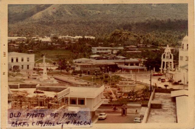
Picture above shows the construction of what is now the Ibalon Hotel at bottom left, the old Rizal Park without the trees,
skating rink at the center, the old churchyard toward the center right, and the City Hall and the old, unsheltered Social
Hall toward the center left. The old Lourdes Hospital can be seen toward the center, while the roof tops of the Iriga Central
School and the former ALATCO buildings can be seen at the top left, and most of Ilian Hill in the background.
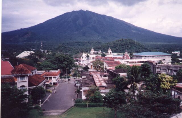
Picture
below is the more recent version of the above picture. See the completed Ibalon Hotel and shopping area across from it. The
much improved city park with a lot of trees and other facilities all the way to the City Hall.
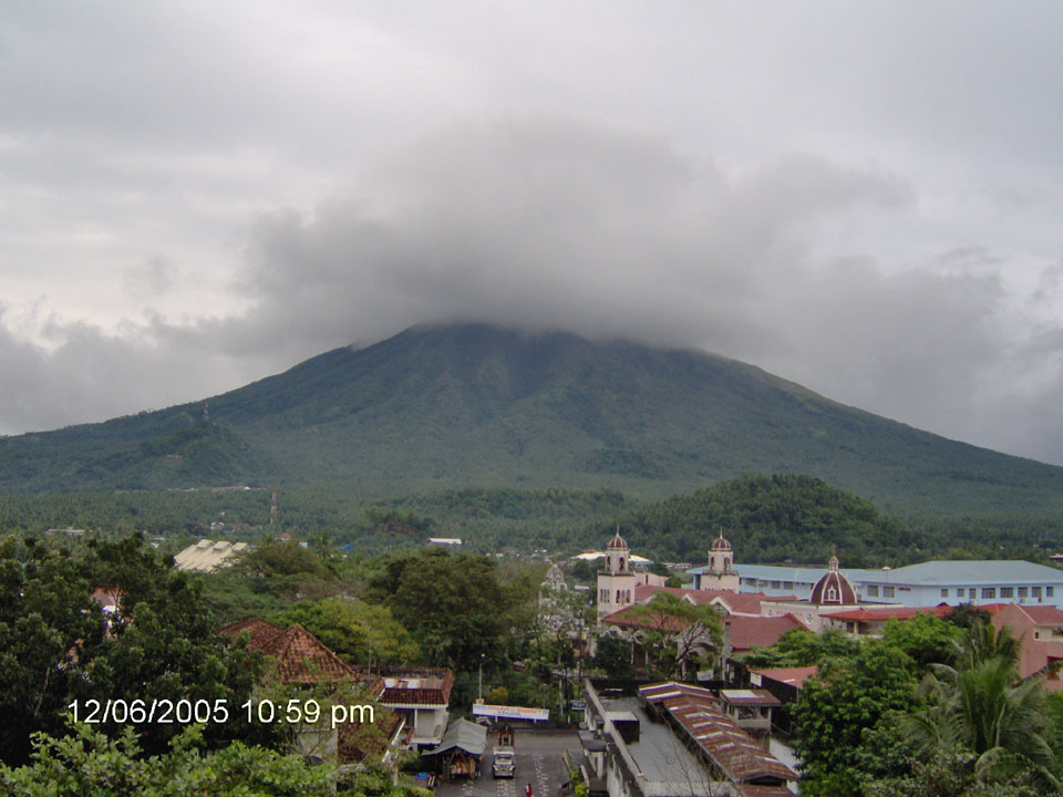
The picture below is the more recent picture of the two pictures above. Note the thick foliage that virtually hides the
town playground and the view to the City Hall. Also note the aging and rusting roofs of the old Ibalon Hotel recently purchased
by Atty. Ortega for unknown business venture and the building across from it. Likewise, note the expanded La Consolacion College
(blue roof).
|